
February 9th – Friends to the rescue
The original plan was to be in the national park early in
the morning, but without a dog sitter this would be impossible. The park was 150 kilometres away from Puerto
Natales with a checkpoint to ensure things like dogs don’t enter that national
park. Thankfully friends of ours
happened to arrive in the area last night and had agreed to look after our
dog. Ben and Annie you are our hero’s.
 |
| This picture reminds us of the front page of our South America Lonely Planet Book |
Our first hike was an easy 5 km round trip to a viewpoint of
Grey Glacier. The hike was beautiful,
easy and made a great introduction to the park.
Between this hike and our next hike of the day we stopped at numerous
miradors doing small walks for slightly different views. Everything felt worth it.
 |
| That\s Gray Glacier in the background |
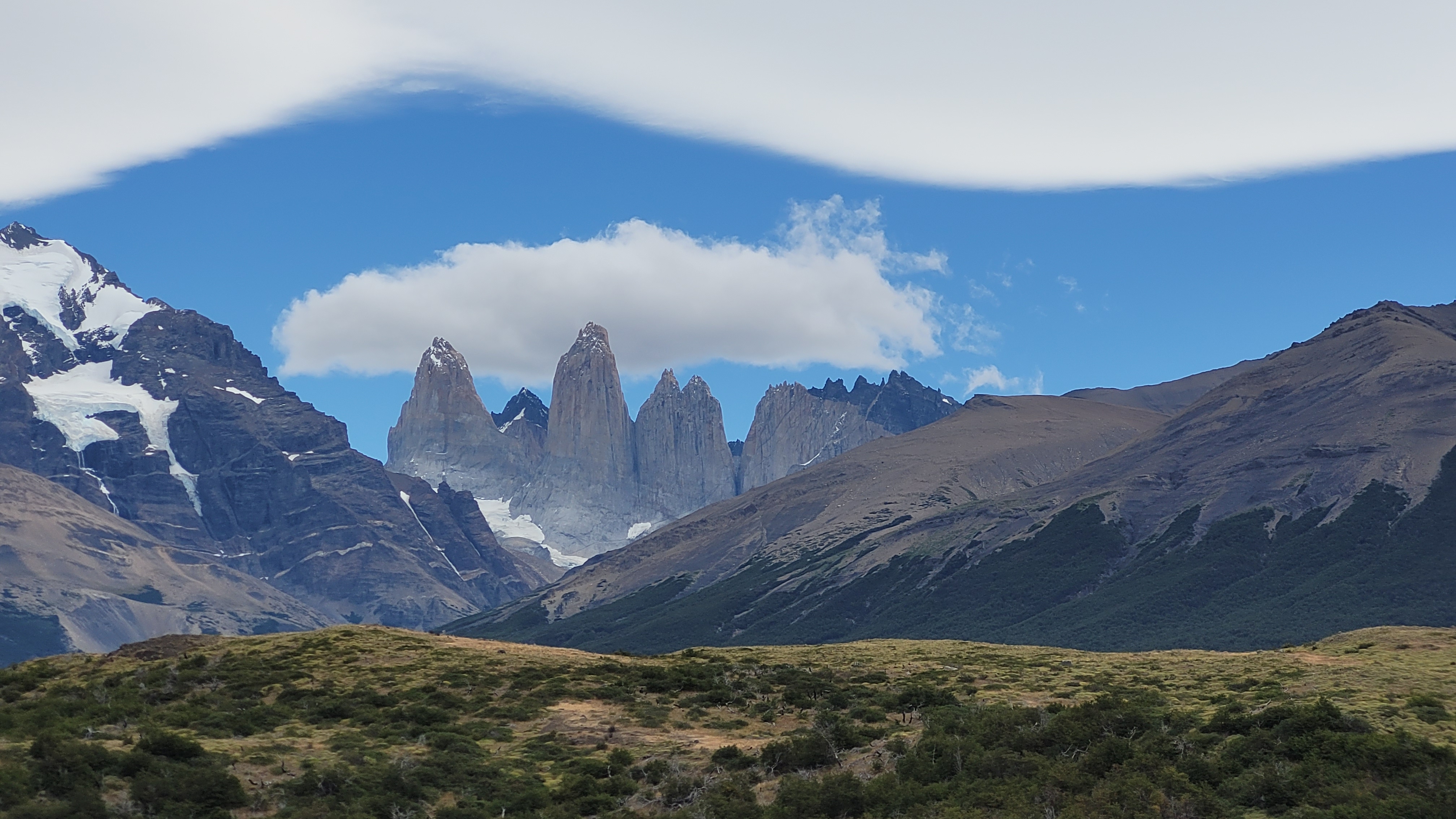
Our final hike of the day was the Curve Mirador which we had
read was the best easy hike in the entire park.
At just over another 7 kilometres round trip this flat walk gave us some
of the most impressive views of the mountain range. It was hard not to just sit and look at these
massive towering mountains.
As a bit of an aside we did still get in trouble in the
park, after working up a bit of an appetite we started our stove and cooked
some soup since $25 USD per meal in the nearby restaurants in the park seemed a
bit ridiculous. Within 10 minutes we had
a random guy run up to us yelling that fires are forbidden in the national
park. We assumed that was campfires, but
nope, according to this guy its all flames.


By 10pm all our food was cooked for tomorrow and our bag was
packed. Our alarm was set with the goal
to be on the trail for 6:30am.
 |
| Breakfast at sunrise |
February 10th – To the towers
As we had planned we were on the trail for 6:30 am. It was almost too early to eat so we started our ascent. After 2 kilometers we were starving, luckily the perfect breakfast spot was just a few steps away where we could sit and watch the sun slowly crest over the mountains.
The hike itself was tough but do-able. The hardest section of the hike was the final
1 kilometer where the steepness of the trail got a little ridiculous, but our
hard work was rewarded with beautiful views of the tower mountains towering
over tower lake. Because of the time we
started we were almost the only ones at the viewpoint making our early morning
walk up completely worth it. We had
reached the end of the trail!!
A mandatory break
 |
| So close... |
 |
| We did it, the towers mirador! |
We opted to not do the final hike we had contemplated doing
while we were in the park, an 11km hike around Laguna Azul, we did however,
drive to the trailhead to see what we would be missing. Definitely another beautiful view but we were
happy with what we had done and we needed to get back to town to retrieve
Rupert.
 |
| The view from Laguna Azul |
The drive back to Puerto Natales was a bit tough with us
constantly switching any song that was too slow in fear that it would put us to
sleep. When we did arrive to the town we
learned our friends were at the local distillery that we had fallen in love
with not 5 days previous so we headed there and spent the next hour or two
chatting and giving Rupert all the cuddles.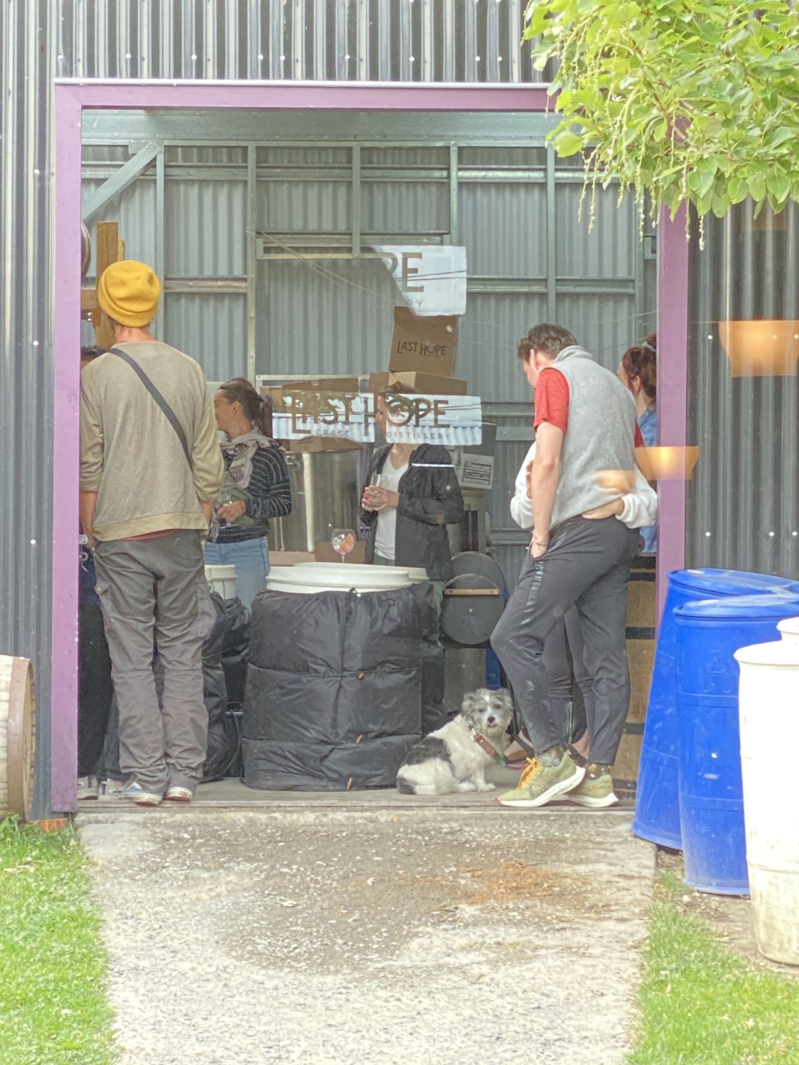
Rupert enjoying a tour
Obviously we didn’t drink much at the distillery since we
were so tired, but when it was
suggested we grab a bottle of wine and head to a
campground to continue all our conversations we couldn’t say no. Needless to say, wine was consumed and by
11pm we were exhausted. It was time for
bed.
February 11th – Re-entering Argentina
It was a slow start for the morning, but by noon we had
finished socializing, eaten breakfast and was ready to finally leave the Puerto
Natales area towards Argentina.
Thank you so much Ben and Annie
The border was uneventful as we are quite used to travelling
between Argentina and Chile now. Paul
almost drove right through the border without a final inspection from Argentina
but after slowly driving through the border an army official ran out and waved
us down. Obviously we had nothing to hide and all the proper documents to
import Rupert into Argentina, so after a 5 minute chat we were back on the
road.

This area of Argentina (Calafate/Chalten) is known to be
quite expensive so we stopped in at the small city of Rio Turbio to purchase
everything we would need for the next week or so. We had hoped to get pretty close to Calafate
tonight, so we drove until we couldn’t mentally drive anymore, to a little
camping spot off the highway overlooking some mountains. We found a little spot with some wind
protection and settled in for the night.
February 12th -
The Purge
Arriving to Calafate was surreal, it was absolutely full of
tourists and would fit in well with any major touristy town in Canada such as
Banff or Whistler. The streets were
lined with companies offering tours and bars selling expensive cocktails and
beer. After dropping off our laundry,
exchanging some of our USD for Argentinian Pesos and finding a campground we
started discussing how we would spend the remainder of the day. We debated
about wandering around the community but we were not in the mood to spend any
money due to the cost of our tour tomorrow, so we decided to do a purge.
All our purged items
Since leaving Canada we have slowly accumulated random
things, some we need and other’s we didn’t.
We also had learned that some of the things we had travelled with for
the entirety of our trip we had never used.
We decided today we would put an end to that and do a large purge of all
the things we don’t need. We ended up
getting rid of 2 medium garbage bags of stuff, which may not seem like a lot
but when everything you have and use can be stored within a Dodge Grand Caravan
we can assure you that this felt like a lot of stuff to get rid of. 
The random business that exchanged our money
February 13th – Trekking on a Glacier
We had to set our alarm to ensure we would be at the pick up
point for our tour by 7:40am. Paul was a
little concerned that we would be late, especially since he remembered
selecting a 7:30am option. Little did we
know that time was for hotel pickups, and our pickup point was one of the last
stops. That didn’t stop us from getting
a little stressed that we somehow missed the bus.
It was a pretty long bus ride into the area of Perito Moreno
Glacier with many curves and turns reminding Paul specifically why he enjoys
being an overlander rather than a backpacker.
Within the last 20 minutes his face was starting to turn white and he
was drinking water frequently to calm his stomach.
That rainbow highlights this glacier perfectly


Eventually we arrived at the glacier which had only started receding for the first time in its history. The Glacier was massive and awe inspiring, definitely a worthwhile thing to see. The sounds of it caving and pieces falling into the water below was mesmerizing. We seemed to luck out with weather as when we arrived there was a bit of rain creating a rainbow over the glacier. When it was time to board the boat to do our glacier trek the sun had come out and the blues of the glacier started to become surreal.

 The hike onto the glacier was good, but we debated at length
after the tour was done if it was worth the large price tag at almost $200 CAD
per person, becoming one of our most expensive tours. We did like our photos and experiences, but
we had been on glaciers before in Canada within the Stewart BC and Jasper AB
area. We have no regrets, but we
wouldn’t do the tour again and wouldn’t recommend the tour to anyone on a tight
budget. What we would recommend is to
grab a bottle of wine go to one of the many balconies overlooking the glacier
and sit and enjoy the show for a couple hours.
Although we didn’t have the wine, that was probably our favourite thing
we did near the glacier.
The hike onto the glacier was good, but we debated at length
after the tour was done if it was worth the large price tag at almost $200 CAD
per person, becoming one of our most expensive tours. We did like our photos and experiences, but
we had been on glaciers before in Canada within the Stewart BC and Jasper AB
area. We have no regrets, but we
wouldn’t do the tour again and wouldn’t recommend the tour to anyone on a tight
budget. What we would recommend is to
grab a bottle of wine go to one of the many balconies overlooking the glacier
and sit and enjoy the show for a couple hours.
Although we didn’t have the wine, that was probably our favourite thing
we did near the glacier.

After returning to El Calafate we grabbed the dog and
checked out a music festival that had just started as well as the various
artisanal markets that had sprung up around the area of the concert. We did think about sitting and taking in the
music, but in the end decided that our day had been busy enough and it was time
to retreat to the van for some shut eye.
We only stopped to grab some sparkling wine to celebrate the last few
nights.
February 14th – Preparing for another long hike
After spending most of the morning hanging around the
campground, and a cute café a quick walk away, it was time to head to our next
destination. The hiking paradise of
Argentinian Patagonia, El Chalten.
 |
| Beginning of the day |
 |
| End of the day: Happy Valentines Day! |
The drive was longer than we had expected since most people talk about Calafate and Chalten like they are spitting distance from each other. What we envisioned was an hour drive took almost 3 hours meaning when we arrived it was already around dinner time. We found a perfect spot at the municipal camping area (more like parking lot) and headed towards the nearest pub for a valentine’s drink. We considered having a meal but the meal costs were a bit eye watering and consisted of pizza and burgers so we grabbed another bottle of wine and cooked a nice chicken dinner as we once again prepared for another long hike to the base of Mountain Fitz Roy.
February 15th – Sick
Paul did not sleep well.
By the time it was time to theoretically start the trail it was evident
that he had a sinus cold and was in no condition to take on a 20 km hike. He instead decided to rest up watching House
on Netflix trying to get better. 
The view from the Mirador de los Condores
Kendra decided instead to do a small hike to the Mirador de
los Condores for some nice views of the valley.
Hopefully tomorrow we can attempt the hike we want to do, together.
February 16th – Up the medicine and the Vitamin C
The alarm went off at 6:30am with the hope that Paul would
be well enough to hit the trail.
Unfortunately, once again it was not meant to be. Paul, slightly frustrated about being sick in
such a beautiful location, marched to the nearby pharmacy to pick up some cold
medicine. He then went to the nearby
supermarket for fresh orange juice. The
Fitz Roy hike is our last must do hike in southern Patagonia and not one we
want to miss out on. Hopefully tomorrow
we will slowly be heading towards the viewpoint famous among many hikers.
February 17th – Forced up Fitz Roy

After parking at the trailhead and preparing the van for
Rupert we started our ascent. We had
read the hike is split into 3 sections, a moderate uphill for 6 kilometers, a
relatively flat section for 3 kilometers and a very steep section for 1
kilometer. Although Paul was feeling
unwell we climbed the first section relatively easily, passing many hikers and
feeling really “fit”. Obviously the flat
section was a breeze and took us through a mountain forest with what should
have been beautiful views of Fitz Roy but unsurprisingly google was a bit off
with its weather predictions. We had
read it was supposed to be nice but alas the mountain was hiding behind some
thick clouds. We did have a daunting
worry that we would do the hike only to be greeted by dense clouds.
 |
| Fitz Roy in all its glory |
After catching our breath (which seemed to take an hour) we
decided to explore the viewpoint area.
We had noticed a small number of people head to a mound on the left hand
side of the mountain lake and wondered what they were doing over there. Our fear of missing out kicked in and we
walked another 0.5 kilometers. Wow are
we glad we did, this mound gave us a totally different perspective of Fitz Roy
and even gave us a view of another glacier lake. Once again our little extra push was well
worth the effort. We even met another
British Colombian at the top who we chatted with as we took in the views.
 |
| We made it to the top! |
 The hike back to the van was amazing, the weather just kept
on improving giving us more great views of the mountain. By the time we returned to the van we both
agreed that this was one of the best “day” hikes we had ever done and couldn’t
believe that 12 hours ago we considered not doing it.
The hike back to the van was amazing, the weather just kept
on improving giving us more great views of the mountain. By the time we returned to the van we both
agreed that this was one of the best “day” hikes we had ever done and couldn’t
believe that 12 hours ago we considered not doing it.
Running on a bit of an endorphin high we decided to extend
our adventure a little bit and drive down a scenic road within the national
park that borders El Chalten. In guide
books it had been described as beautiful, and although it was, it reminded us
of home giving us and odd homesick feeling.
In general the drive probably wasn’t worth the gas but we find it hard
to not do something, as always the fear of missing out drives us, at least we
got to see a nice waterfall.
It looks better than it tasted :(
The celebratory meal did not compliment the accomplishment
like we had hoped, El Chalten is a touristy town and as such most restaurants
cater to one time patrons. Quality is
not something they strive for. This was
fine for Paul who ordered the cheapest thing on the menu as he was feeling
quite ill after pushing himself a little too hard, but for Kendra who decided
to splurge on a smoked lamb dinner it was quite disappointing. At least the wine we purchased after the meal
was a predictably delicious Argentinian wine!
February 18th – What we will do to save money
We woke up to a flat tire and of course today is Sunday
meaning that nothing is the small tourist town is open. We had a few options. The first was to stay
in Chalten, but we were out of groceries and food in the town was, no
exaggeration, 50% more expensive that a normal community and the person who
would fix the tire was also very expensive.
The second option was to leave the town and stop every 30 minutes to
pump up the tire with our air compressor, the lazy option meaning we wouldn’t
need to remove the tire from the roof and mount it on the van. The final option
is what we did, the smart option, take the spare down from the roof and find a
place to put the flat tire in the van.
Definitely the best option, just sometimes it would be nice to just get
away with taking the easy route.
Preparing to switch the tire

Switch complete
The drive to Gobernador Gregores took us longer than
planned, mostly due to poor road quality making us very happy we had taken the
time to swap tires, unfortunately the tire shop in the community was closed
until Monday so we did the only logical thing, slept down by the local river in
our van.
A tire repair that would have cost of $25 CAD in El Chalten
cost of $7 CAD in Gobernador Gregores.
It would have cost more if the guy had swapped the tire back on our
vehicle, but Paul decided to do the work himself and save that $3 CAD.
The Cave of the Hands
 There was not much more to do in the community so we headed
back to the highway towards the last thing we wanted to see in the Santa Cruz
Province, The Cave of the Hands. This
historical area was home to local indigenous people starting 8000 years
ago. These people were nomadic following
the guanacos. The caves were located in
a long canyon with a temperate climate near a water source. In the cave they painted various animals but
mostly there hands using the negative space there hands created. Because of where they were placed they were
incredibly well preserved making it a surreal hike to see things placed by
humans thousands of years in the past that look like the could have been placed
a few decades ago. The hands looked
so…human, so much like our own. For some
reason we envisioned these Neanderthals' with hands different than our own. Sometimes it feels like we think about people
from so long ago as these subspecies of humans.
Beings that will evolve into modern humans but here were hands that looked
just like ours. There were hands of
children and elderly besides drawing of beasts and the night sky. It was humbling.
There was not much more to do in the community so we headed
back to the highway towards the last thing we wanted to see in the Santa Cruz
Province, The Cave of the Hands. This
historical area was home to local indigenous people starting 8000 years
ago. These people were nomadic following
the guanacos. The caves were located in
a long canyon with a temperate climate near a water source. In the cave they painted various animals but
mostly there hands using the negative space there hands created. Because of where they were placed they were
incredibly well preserved making it a surreal hike to see things placed by
humans thousands of years in the past that look like the could have been placed
a few decades ago. The hands looked
so…human, so much like our own. For some
reason we envisioned these Neanderthals' with hands different than our own. Sometimes it feels like we think about people
from so long ago as these subspecies of humans.
Beings that will evolve into modern humans but here were hands that looked
just like ours. There were hands of
children and elderly besides drawing of beasts and the night sky. It was humbling.
 After finishing our final must see in the area we turned off
the highway down a small dirt road indistinguishable from some of the roads
going to random homesteads in the area.
The only difference is this road had a small sign saying Paso
Roballo. This mountain pass marks the
most rural border crossing between Argentina and Chile a normal vehicle can
take and the border we had chosen to drive to.
The only issue is that the gravel road, which was over 200 kilometres
long, would take us through the middle of nowhere. The drive was supposed to be beautiful and
worth it but we were having flashbacks to the last rural border we had driven
to which consisted of a gravel road; our drive from Bolivia to Chile where we
had to be towed into Chile.
After finishing our final must see in the area we turned off
the highway down a small dirt road indistinguishable from some of the roads
going to random homesteads in the area.
The only difference is this road had a small sign saying Paso
Roballo. This mountain pass marks the
most rural border crossing between Argentina and Chile a normal vehicle can
take and the border we had chosen to drive to.
The only issue is that the gravel road, which was over 200 kilometres
long, would take us through the middle of nowhere. The drive was supposed to be beautiful and
worth it but we were having flashbacks to the last rural border we had driven
to which consisted of a gravel road; our drive from Bolivia to Chile where we
had to be towed into Chile.
Thankfully the road was in far better condition than we
expected and was as beautiful as people had described. However, after 50 kilometres we decided it
was time to relax for the night so we pulled into a spot known for beautiful
sunsets.
February 20th – A Retro Border crossing
Our breakfast this morning consisted of every fresh or
perishable item we had as we knew from experience that Chile was very strict
with what items were not allowed in the country. After making sure we were adequately full and
hiding the few random items we could bare to eat (raw garlic for example) we
drove the remaining 50 kilometres to the Argentina border post.
Leaving Argentina
The drive was beautiful but getting to the border felt like
we had gone back in time. Since there
was no internet connection at this border everything was done on paper and by
hand. Our information was placed in a
ledger where we confirmed everything was correct. Even the building didn’t fell like it was
part of the current era. It was a small
two room log cabin where the room was lit but the sun shining through a large
window. There was something so beautifully simple about the process.

Made it to Chile
There were many reasons we chose this border. As we said before it was a beautiful drive,
and it also got us closest to where we wanted to be in Chile (the southern
section of the Carretera Austral) but the final reason may be a little odd to
most people. By coming to this border,
we would get a stamp in our passport. Argentina
does everything electronically meaning that unless you require a visa to enter
the country which requires a stamp to indicate it has been used, you do not get
a stamp, ever. Many overlanders make
jokes how they will have multiple pages in their passports full with Chillian
Immigration stamps. Well because there
is no internet at this border we got an Argentina exit stamp. Our passport contained proof we went to
Argentina!

The final 100 kilometres into Chile was through their
Patagonia National Park. We plan to
visit this park later, but since we were low on water and food we had to go to
the largest city in the region known as Cochrane, which was south of the park. This community would mark the first community
we would visit on the Carretera Austral a route famous for mountains, lakes,
hikes and general ruggedness. It had
become a must do highway for anyone thinking of doing a roadtrip in Chile. Our plan was to drive south on the highway to
near the end of it before slowly starting to drive up. We had no plans to send any time in Cochrane
today but destiny seemed have other plans.
As we walked down the street of the small community, which
reminded us of small communities in the Kootenays, we see a tall bearded man
run up to us saying “I knew I recognized that van”. Within a few moments we recognized it as
Sebastian a US resident we had first met in Mexico and again in Guatemala. He and his partner Diamond had become friends
of ours, we had messaged dozens of times throughout this trip and we had hoped
our paths would cross again but where unsure if or where it would happen due to
poor cell service within these rural areas.
As you could imagine we headed to the nearest pub ordered a couple of
pints and a couple pizzas and before we knew it hours had passed. We would have to change our plans and camp
nearby but we could not have been happier to see these two again. Unfortunately they had to head to Argentina
so we once again parted ways and headed to a small lake just south of the
community to relax for the rest of the night.
Relaxing in Chile!
February 21st – Boardwalks on the sea

Cartel Tortel was a logging community built on the shores of
a fiord previously only accessible by boat.
As there were no need to think about the modern automobile there was no
need to think about how to accommodate vehicles so the entire community is only
accessible by boardwalks with the community itself stretching for a kilometer
or so on the shore. Most “major”
destination are within its downtown which happen to be at least 750 metres walk
from the only place to park a vehicle to access the community.


 |
| Now that is one dirty dog! |
We had planned to only spend a few hours in the community
before returning to the spot we had camped the previous night, but the sun had
started to set by the time we reached the van and ended our hike. After trying out a few random campsites seen
on iOverlander we settled on a spot used by highway maintenance during the
winter to deposit and pick up gravel. It
wasn’t perfect but did give us a nice view of a couple mountains in the
distance.
 |
| Made it to the top! |
February 22nd – Not really feeling it
We didn’t have much of a plan for the day. We knew the next “must do” for ourselves was
a 21 kilometre hike within Patagonia National Park which would be impossible to
do today, unless we woke up at 6 am. The
starting point of the hike was a few hours away from where we had camped and
the weather was set to be poor most of the day.

When we finally arrived back at our small lake camp site we had stayed the previous night we became more confident in our plan as we watched dark clouds approach the areas of the hiking paths we wanted to follow. We knew we had absolutely made the correct decision when we looked up at the mountains to the north of us and saw they were white; the clouds where snow clouds.
Throughout the last few weeks, we had become more and more
happy with our decision to take Argentina Route 3 and “rush” to Ushuaia. We had seen the trees slowly change colour in
Punta Areana and now we were seeing snow, be it at high altitude. Regardless, it was clear the seasons were
changing.
We did go into Cochrane, the community closest to our
camping spot for a few provisions. We
purchased mostly comfort food for the hike we plan to do tomorrow and a couple
beers to drink beside the lake which we thoroughly enjoyed.
February 23rd – Watching Cougars hunt their prey
One of the hardest things for us to do in Patagonia is do
things “with” Rupert. In general, all
national parks are not dog friendly and frustratingly that means they are not
welcome even if they stay within the vehicle.
This means that if we do do anything in a National Park we have to hide
Rupert then once we park make sure that no one will notice that a dog is
relaxing in the van. To accomplish this
task and ensure we have the best weather we can have while doing the “must do”
21 kilometre hike within Patagonia National Park we wanted to be on the trail
for 9am.
The wildlife decided to greet us
as we entered the park

 |
| Dinner for a "Puma" |
A few of our friends had previously entered and explored the
park but had not seen the famous “puma” highlighted heavily in its promotional
material. We were ecstatic to be driving
through the park and see one, which started another big discussion. What is a Puma? Paul was convinced that they had not seen a
Puma and had instead seen a Cougar.
Kendra was convinced that a Puma must be a large cat, not unlike a
cougar, but with a bushy tail. When we
started our 21 kilometre hike we finally had our answer of what we had seen and
we were both, kind of, incorrect. In
Spanish Puma means Cougar meaning we were in a national park famous of cougars
and we were lucky enough to have seen one.
We laughed at this realization; glad we had seen one while we were in
the safety of our van.

This was the 3rd 20+ kilometre hike we had done in the last couple weeks. We had been told it was the best hike within this national park but it was not comparable to the amazing hike we had done to Torres del Paine and Fitz Roy. We did enjoy it and it would have been quasi forgettable until the last 4 kilometres of the hike when some Guanacos in the distance started to make a sound we had never heard before.
We frantically took out the camera and started to film the
odd sound the guanacos made, trying to figure out why they were making such an
odd sound. We thought maybe it was
mating season or maybe it was just general communication until we learned the
truth; there was a cougar stocking them.
After a couple minutes of making the unusual sound they ran as fast as
they could up a steep hill. It was at
that point we noticed the cougar, maybe 75 metres away from us. It was silent and stealthy making calculated
moves to reach the guanacos. All of a
sudden we became very aware we had no bear spray or anything really to defend
ourself if the cougar decided that we would be easier prey. Needless to say we spent the remained our the
hike watching our back becoming hyperaware of our surroundings, praying we
wouldn’t be a cougars consolation prize.
A bit too close for comfort!

We survived, obviously.
We never did see the cougar stalking us and felt quite relieved when we
arrived back at the van. So much so we
didn’t stay too much longer in the park.
We quickly got Rupert settled and prepared the van to be driven. Our final stop of the night was near the
confluence of two rivers making a perfect backdrop for a homecooked meal out
the back of the van as we looked at pictures showing a cougar that was a bit
too close for comfort.


No comments:
Post a Comment